
 This week is National Geography Awareness Week, and Friday, November 21, marks the one-year anniversary of the naming of the Paul W. Stout Map Collection on the second floor of Bracken Library. In 2024, University Libraries paid tribute to the late map librarian who joined the Map Collection at Ball State University Libraries in 1976.
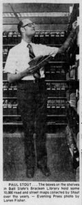
Paul W. Stout immediately began working to expand its original collection of around 10,000 maps to the current size of over 140,000 maps, atlases, and other cartographic resources. Back then, the Map Collection was located in the space where the dean’s office is today.
For many years, Stout worked at the Library of Congress Map Division’s Summer Cartographic Workshop. In exchange for his time, he received thousands of maps for the BSU collection. For Paul, this became a competitive challenge—a treasure hunt—and he was able to acquire unique maps for Bracken Library. One year, Paul discovered a map in the stacks that was published in 1919 at the end of World War I. The map was produced in four languages, was massive in size, and had handwritten notes along its edge. Paul did some research and discovered that the map was used at the signing of the Treaty of Trianon, which divided the countries of Hungary and Romania after the war. He returned it to the librarian immediately, who was undoubtedly grateful to Paul for this oversight. It turns out the map was one of two used at that treaty-signing, so at the end of the workshop, the librarian gave the second map to Paul. (It’s now housed in Archives and Special Collections).
Melissa Gentry, Supervisor of the Paul W. Stout Map Collection, began working for Stout in 2001. “He was a cartographic genius, a preeminent scholar, knowledgeable about maps obviously, but also their associated history and the sociological and political stories they told. Every map was a lesson.”
Dr. Amy Petts, Associate Dean for Strategic Engagement and Learning, highlighted the importance of this extraordinary collection:
Historical and contemporary maps serve as essential tools in the pursuit of knowledge, offering critical insights into the development of societies and the world around us. Maps provide a sense of place, allowing us to trace the paths of cultures, ideas, and movements, deepening our understanding of both our personal and collective identities. They preserve history, acting as living records of geopolitical shifts, exploration, and transformation. Through maps, we can better grasp complex concepts in fields like politics, economics, and environmental science, all through the powerful lens of spatial understanding. Ultimately, the study and use of maps empower us to navigate the world with purpose, fostering intellectual growth and a deeper connection to both the past and the present.
The Map Collection today is a vibrant center for research and learning, providing customized instructional sessions for departments across campus and for the broader community. Maps from the collection have been incorporated into countless immersive learning projects, and students from the School of Art are even creating new maps for the library. And thanks to the broad scope of the collection curated by Stout, every year thousands of reference questions are fielded from around the world.
Paul W. Stout retired from the University in 2003 but remained active in the community. He was a dedicated volunteer, a curious traveler, and an advocate for the underdog and civil rights. He was also a loyal Ball State Cardinals fan. To borrow from map terminology, Paul W. Stout was a legend. This Collection will be a lasting tribute to his decades of dedication and service to the Ball State University community.